
Ah!. Madaba, Jordan!. More on this topic later. So you have obviously finished the Israel trail. How was the remaining of the trail [from Jerusalem to Tel Dan]?
Very beautiful, like all of the trail so far. Israel is a small country but there is everything, desert, mountains, beaches, plains, forests ...It is a green country because of the agriculture, but also because one important aspect of the Zionist being is `making a garden of the desert` meaning that all over the country groves, forests, trees are planted.

From Tel Aviv on the shvil passed right beside the sea. I was walking on the beach which was very beautiful. At Caesaria you pass the ancient harbor, the port. Although in roman times the site was destroyed by an earthquake the Ottomans built huge walls around it.


Although it is a country with a lot of history [remains of Romans, crusaders, ottomans etc.] the towns you pass are relatively young. There are not really towns: what you find in Israel are Kibbutzes, Moshav or a Kfar [which is a real village].

Where an Arab village is an open village, a Kibbutz/ Moshav has a fence, often its own petrol station, bomb shelters and one mini market. In a way you can see it as a village but to me it was quite artificial. The inhabitants live in nice, quite big houses with everything: water, electricity and designed to be in some way autonomous. Sometimes I could see from which they lived [agricultural, winery, tourism] but often it was quite mysterious to me: what the hell these people do for a living that they live in such nice houses, and drive in such fancy cars?.

In E`lat I went in to buy some food: a supernew, ultra-ortodox settlement/ urbanization again with a huge fence around it, one entrance with dito security and an almost infinite amount of buses serving the people. The people looked to me like Jews from Russia a century ago, very bleak, white, with this typical hairstyle and black clothes.

Did you encounter on your hike a town/ city which was shared Jewish/ Arab?
Not really. Maybe Nazareth. Nazareth is an open city where the historical center is arab. That is also quite confusing: you cannot really say `Arabs` because there are also Christians [that speak arab], Druze [a religious sect which members also speak Arabic] in Israel.

In Nazareth you have many Arab Christians where the Israelis [Jews] live in Nazareth Illit [New Nazareth], a vast urbanization outside the historical center with wide lanes, trees, flats like in Russia. But still, it maybe looked like one city but it is not: the Jews live in their neighborhoods, and the `Arabs` in theirs ...


SO, to answer your question, I found one place where Jews and Arabs live together: in Latrun. Latrun is a christian monastery that leased [and later gave] land to Jews and Arabs to build a shared community.

Israel cherishes its `war of independence`: on the road from Jerusalem to Latrun you see many signs, small monuments that commemorate this event.

So you passed Arab villages in Israel. How do they look like?. Did you see also traces of those [Palestinians] who flew for the violence of 1948 to refugee camps in Gaza and the west bank?
An Arab village in Israel is [for what I saw] a bunch of three store flats crammed in a kind of chaotic way together on a hill. There is a mosque, mini market on level zero of such a three-store-flat. I guess the whole family lives together [first and second generation together] that they build such homes.

Apart from those who didn`t flee you see little trace. It seems that all the abandoned Arab villages have been disappeared. Villages have been bulldozed over and changed into farmland, national parks or archaeological sites [many Arab villages were built on Byzantine remains]. An interesting example is Mitzpori, an ancient roman site 8 kms outside Nazareth. It is now turned into an archeological park with a roman villa, a roman road, ancient frescoes [with the `Mona Lisa of the Galilee`] and on top of the hill a crusader castle.

Very interesting and educative, everything is explained -which is nice- and also with the accent on the importance of the `Jewish heritage`. It was the place where the Jews that during the big revolt against Rome didn`t take part in the revolt and thus were allowed by the Romans to keep on living there.


At the top of the hill you can read about the excavations and there is a picture of the 1930`s of an american professor leading the excavations. More interesting is a picture of the site during the `30: the complete hill is an arab village with on top of the hill the crusader tower in which the village school was located.

... mosaic to measure the water level of the river Nile!, Nile villa, Mitspori

... the ancient light tower of Alexandria, Nile villa, Mitspori
You see villagers in Jallabya and with turbans wrindled around their heads helping with the excavations. Quite cynical if you concern that about 18 years later they all were forced to leave and that possibly the importance of the site was the cause of it.

I am not a detective but if you look very good you see little remains of houses. More obvious are the cactusses: the Arab inhabitants of that time used cactusses as a kind of fence around their domains. Israelis don`t use cactusses to let themselves feel secure: they use metal fences [often under current], barbed wire. On the Mitzpori hill today you see almost a forest of cactusses!.

Did you also visit all these holy sites at the sea of Galilee?
The shvil doesn`t really go there, in fact does not even touch the sea of Galilee, but I left the shvil because I wanted to follow the shore of the sea of Galilee. At Yardenit there is the site where it is claimed that Jesus had performed his baptizings.

I didn`t visit it, the sight of all these touringcars, and all the circus around it made it lost its attraction to me. North of the sea there are all those monasteries, churches and the place where Jesus should have changed water into wine [Capernaum].


No, I guess I am not really a believer haha. I feel the most happy when I am in the nature and the shvil gave me this possibility.
And finally you reached the north, the Hula valley with on the other side the Golan hights ...
I reached Kiryat Shmona, a quite big city very close to the border with Lebanon. A very beautiful area with a spectacular view of Mount Hermon with its top covered with snow!. Kibbutz Tel Dan was the end point of the trail, from there I followed a trail through a wadi to Banya falls, the highest waterfall in Israel and after a path to Nimrod castle, a Mameluk castle from the twelfth century.


And then?. Did you take the bus back to Eilat?
Nah ...no, my plan was to hike south, to Beit She`an, which is the border with Jordan, cross the border and return back into Israel thus acquiring a Jordanian visa and renewing my Israeli visa [it had almost expired].


Did you follow another trail back south?
Yeah, a very beautiful one, de shvil haGolan [Golan trail]!.


The Golan hights is territory which used to be from Syria and was conquered by Israel in the six day war of 1967. The Golan trail leads you through minefields, bunkers, tanks and through a former Syrian military base.

Why the Golan was taken in 1967 and how can you tell if a [former] military base is Syrian or Israeli?.
The Syrians used the Golan hights to shell the settlements in the lower Galilee so Israel took it because of its strategic importance and to stop the shelling of its settlements.


The story behind the Syrian military installations in the Golan is funny because it is a nice example of stupidity. In 1960 a top Israeli spy managed to climb up in the Syrian military ranks to become even deputy minister of the minister of defense. In this position he was able to visit all the military installations in the Golan and even take pictures [with fellow Syrian colleagues] in the Golan. In his function he convinced the Syrian military to plant Eucalyptus trees around the canons aimed at the Galilee enabling thus the Israelis knowing the exact positions of the Syrians [the Eucalyptus is a very high tree and not original vegetation in the Golan].

The super spy was disguised in 1965 and hanged in front of the rolling cameras but two years later the Syrian army in the Golan was defeated by the Israelis in hours, thanks to his eucalyptus idea ...

The Syrian armament is now gone but the Eucalyptus trees are still visible, planted in an orderly way. I camped even in a destroyed Syrian army base. Imagine an almost destroyed mosque, covered with numerous bullet holes, surrounded by simple concrete little houses, also with many bullet holes in its walls, earth walls which covered the tanks and numerous Eucalyptus trees ...

Did you notice something of the actual problems in Syria now?
At the end of the Shvil Israel, while hiking to Nimrod castle you hear almost constantly the heavy shelling, the pum pum pum coming from Syria. It is sad what is going on there, also a part of the Golan trail follows the road because otherwise you are too close to the Syrian border.


... sea of Kinneret
... And then the border trick at Bet She`an, did it work out?.
Oh yeah..[as I thought]. I got the Jordanian visa [that expired the same day, because I left Jordan at Sheikh Hussein bridge, and not at Allenby bridge, I didn`t know this] and got a new three month Israeli visa!.

... And after the land of the Philistines!. How did it look like?.
To me like another country. Jenin is six kilometers from the fence that separates Palestine with Israel. There was a checkpoint, but the border crossing went smoothly: I had to show only my passport, but also there was movement from persons, cars from Israel into Palestine. The difference between the two territories is striking: the road suddenly degrades, there are people beside the road offering agricultural goods, or other products. No trees anymore, everywhere houses, a densely populated area.
Jenin itself is small, with a soukh, a town center, but what it makes it big are the large surrounding refugee camps. The first encounter with a Palestine was a nice one: I wanted to buy three oranges but he refused to take money from me. He said to me with a smile: `inta dafaE fy Filistyne` [you are travelling in Palestine!].

The Jews call these territories Judea and Samaria. Samaria is the area of Jenin and Nablus and a quite dry environment. In the Palestinian territories is a complex system of area which is controlled by the P.A.[Palestinian Authority], the IDF [Israeli Defense Forces] and territory with both P.A. and IDF.

Judea is the most important part for the Jews, it is seen as their origin, and from the kingdom of Judea the `Great Revolt` against the Roman Empire started.
Did you feel unsafe while hiking through places like Jenin, Nablus which are places of resistance against the Israeli occupation?.
Nah. It were actually soldiers of the IDF I was a bit afraid of. I passed Palestinian towns and villages because I took Palestinian roads [some roads are exclusively for Israeli settlers and are forbidden for Palestinians, at least, that was what my Israeli map was saying. Later I found out that all roads are open now].

At the beginning I felt a bit uncomfortable because Palestinians were staring at me as if they saw water burning, quite a difference compared to being in Israel where I was all the time in the nature and could be anonymous. But I never felt unsafe, on the contrary. The people were very friendly even if some of them thought I was an Israeli.
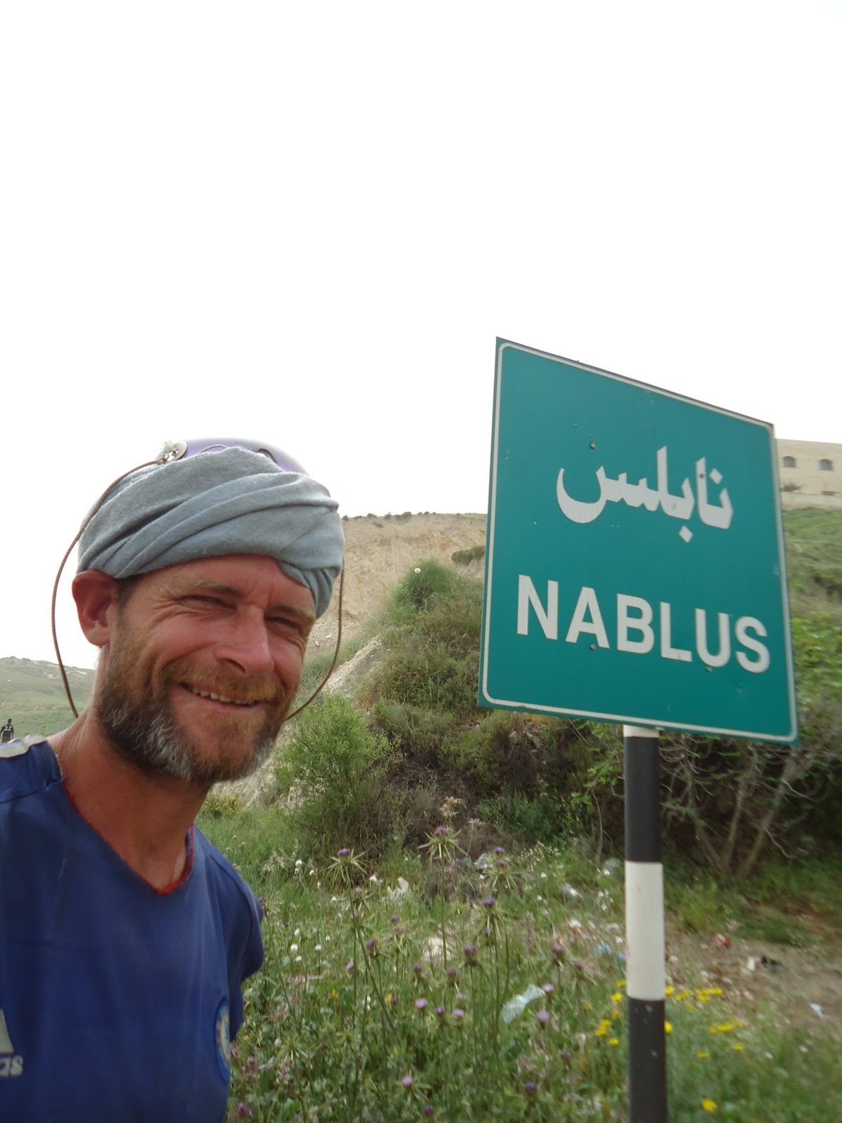
A place like Nablus looked like Egypt, the middle east to me: dust, lot of traffic, dirty, street vendors, Palestinian gendarmerie armed with kalashnikovs, a tea house where you can smoke the Hooka.
At the exit of Nablus I passed an Israeli checkpoint, where two soldiers started to shout at me in Hebrew. One of them came down from the stupid concrete tower, waved his gun in my direction, and ordered me quite aggressively that I had to come to him. I saw the fear in his eyes, he was tensed and that makes people dangerous.

When I said to him: `ani lo medaber Ievrit. Ata medaber Anglit?` [I don`t speak Hebrew. Do you speak English?] he calmed down while his comrade asking me if I was aware that Nablus is a dangerous place, full of terrorists?!. But they eased when I told them I had hiked the shvil Israel and was on my way to the south. They even offered me water and food.
So asphalt road all the time in the Palestinian territories eye?
Unfortunately yes, although there are plans to make the abraham trail [that runs in Palestine, Israel- Be`er Sheva, Jordan, Syria and Turkey] but you need a guide, and I don`t want to hike all the time with a guide.
I hiked on the busy Tariq al Quds [Jerusalem road] but it was very strenuous for me [lots of traffic, people shouting at me, almost no space to hike] so I took the Allon road instead. The Allon road is parallel to the Jerusalem road and connects Israeli settlements. Interesting to hike on it, sometimes I left it to go into a Palestinian village to buy some food, or to hike into an Israeli settlement to have a coffee.

The people [both Israelis and Palestinians] are without exception nice to me: a young Palestinian that guides me through the town to the hidden mini market, the security Habesja at the settlement that almost freaks out when I speak Amarinha to him [many Habesjas came as a refugee to Israel and are now Israelis] and tell him that I was in Ethiopia.
The surprise came at Wadi Kelt: a marked hike trail from the Allon settlement all the way through the Wadi, alongside a river [!]- to a Greek orthodox monastery [St. George] and finally into the Palestinian city Jericho, passing by the ruins of a palace of Herod the Great.
Besides that you were in a [desert] nature again, what made this wadi so special?.
I was very happy to leave the asphalt, but I was literally moving through different worlds: imagine orthodox jews from the nearby settlement taking a dip in the stream, almost together with Palestinians... Maybe I was at the one and only place where both groups more or less meet without conflict, armed soldiers/ settlers. I didn`t see them interact but at least they were enjoying nature together.

Apart from that I found myself [after having left the noisy visitors behind me] in some kind of biblical scene. Imagine a raw, desert like environment, with caves that long time ago were inhabited [you still see the traces of humans at the beginning of caves located in really almost unreachable high -in -the - wadi- rock-wall. You see paths, walls made of stone ... At the bottom of the canyon a water stream, with trees, green grass... The wadi was descending to Jericho, the dead sea level, and the trail was following a still working aqueduct, almost on top of the wadi.

After about ten kilometers I arrive at an orthodox Greek monastery, build on the bottom of the wadi and with a high tower. Inside I find Greek orthodox priests from Greece, Greek icons, visitors dressed in black. I have a break there and continue through the wadi, in front of me Jericho: a plain with palm trees, and urbanization.
Because I follow a wadi there is no israeli checkpoint, but at the exit of the town there is, although cars with mixed numberplates [green for the palestinians yellow for the Israelis] move in and out without being checked or stopped. To me it is very confusing.
Straight is the road to Allenby border crossing. At the beginning at a checkpoint I am stopped by Israeli soldiers, I am not allowed to hike to the border station, I have to take a cab. The Palestinian cab driver assures me that a next Intifadah is coming, because the IDF killed two young demonstrators near Tulkarem yesterday ...
You are now three days in Jordan, how is it so far?. Which itinerary are you following?.
Good!. Like in Palestine the people are very nice, generous to me. I don`t have a good map of Jordan, so I took a kind of detour to arrive in Madaba, the starting point for me of the King`s high way [At-tariq al soultani]!.
... King`s high way?.
... An ancient road connecting the capital of Jordan, Amman with the south, Aqaba. A road that was for centuries taken by Romans, Nabateans, Pilgrims, Crusaders, Muslim armies, trade caravans on their way to Jerusalem!. The spline of the country!.
What kind of city is Madaba?
It is a touristic town, surrounded by mosques and urbanization on a high green plane. The historical center however is dominated by christian churches [Catholics, Greek orthodoxes]. In the byzantine era the place was famous for its mosaics and an old ancient mosaic map depicting the important places of the old world like Jerusalem [see picture one], Jericho, Bethlehem can be visited at the St. George church.
Listo pues hermano, have fun, hasta la proxima!.


Geen opmerkingen:
Een reactie posten